

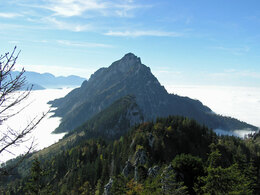
Steineck and Trapez - from Scharnstein and St. Konrad


- Suitable for families
Interactive elevation profile
Create PDF
Tour-Details
Path number: E, 10 & 413
Starting place: 4817 St. Konrad
Destination: 4644 Scharnstein
duration: 3h 31m
length: 6,5 km
Altitude difference (uphill): 799m
Altitude difference (downhill): 71m
Lowest point: 602m
Highest point: 1.358m
difficulty: medium
condition: medium
panoramic view: Great panorama
Paths covering:
Gravel, unfixed, Hiking trail
powered by TOURDATA
Mountain hike with a wonderful view of the Traunstein and the Almtal
The hike starts either at the St. Konrad Dürnberg bus stop or at the parking lot right next to the B 120 still in the municipality of St. Konrad.
Follow the road, past the Dürnberg to the barrier, along the forest road for about 2 km into the forest (signposted Laudachsee). Hiking trails (trail no. 10) and forest roads take you to Jagdhaus Schrattenau (981m). The well-marked trail continues on the forest road for around 100m southwards to a gravel pit. Immediately afterwards, turn right off the forest road. However, you can also cut off the forest road just behind the hunting lodge on a marked hiking trail. Hiking trail no. 10 leads directly to the summit.
Shortly before the summit, you can branch off to the neighboring summit (Trapez).
The descent is via the same route
Characteristics:
beautiful mountain hike on well-marked and signposted paths, surefootedness required at the summit, descent to Jagdhaus Schrattenau via the same route.
Option 2: from Scharnstein via Hochbuchegg:
The hike starts either at the parking lot at the Scharnstein Flugplatz junction right next to the B 120 or directly from Scharnstein-Mühldorf train station
Follow the road to the junction in the direction of Güterweg Hochbuchegg, after approx. 300 meters the signposting for hiking trail 413 or Salzkammergut BergeSeenTrail begins. Follow this uphill, past Hochbuchegg to the barrier, along the forest road for about 2 km into the forest (signposted Laudachsee or Schrattenau) until you reach Jagdhaus Schrattenau (981m). The well-marked trail continues along the forest road for around 100m southwards to a gravel pit. Immediately afterwards, turn right off the forest road. However, you can also cut off the forest road just behind the hunting lodge on a marked hiking trail. Hiking trail no. 10 leads directly to the summit.
Shortly before the summit, you can branch off to the neighboring summit (Trapez).
The descent is via the same route
Maps: Compass No. 19, Freytag & Berndt No. 81, nature experience map of the Traunsee-Almtal region, local maps of St. Konrad and Scharnstein
Accessibility / arrival
Travel either to Gmunden with the Salzkammergutbahn or to Scharnstein with the Almtalbahn:
Gmunden: on the Western Railway line (100) to Attnang-Puchheim (ÖBB Railjet, Western Railway), change to the Salzkammergutbahn (line 170) to Gmunden station. Change to bus line 533 or take the Traunsee Tram to Eisengattern, change to the Salzkammergut Shuttle Route 52 to St. Konrad.
Scharnstein: take the Westbahn line to Wels Hbf (ÖBB and Westbahn), change to the Almtalbahn (line 153) in the direction of Grünau im Almtal "Almtalbahn" to the Scharnstein-Mühldorf stop.
Walk directly from the station up to the Steineck - approx. 3 hours 45 minutes.
By bus:
Bus route 533/535 Gmunden - Scharnstein - Grünau - Almsee, bus stop St. Konrad Dürnberg or bus stop Scharnstein In der Thann - follow the hiking trail on foot.
with the Salzkammergut Shuttle Service Traunsee-Almtal Route 52 from Laakirchen or Kirchham - Scharnstein to the St. Konrad Imbisstube stop, please call the cab center at least 1 hour in advance on 050-422 422 and order.
by bike:
Coming from Gmunden (connection to R4 Traunradweg and R2 Salzkammergut Radweg) or from Scharnstein (connection to R 11 Almtalradweg) on the Traunviertel Tour, 2nd stage to St. Konrad.
In St. Konrad access to Schrattenau possible
From Scharnstein access only possible via MTB route in Hauergraben!
By car:
St. Konrad:
Highway A1 Westautobahn from Vienna Exit 207 Exit Vorchdorf at the traffic circle - direction Gmunden - junction Eisengattern direction St. Konrad, approx. 13 km
Highway A1 Westautobahn from Salzburg Exit 224 Exit Regau - B 145 in the direction of Gmunden - before Gmunden turn onto the B 120 in the direction of Scharnstein, to St. Konrad, approx. 15 km
Parking lot at the bathing lake
Scharnstein:
Highway A1 Westautobahn from Vienna Exit 207 Exit Vorchdorf at the traffic circle - direction Gmunden - turn off Eisengattern direction St. Konrad, continue on the B120 to Scharnstein
Highway A1 Westautobahn from Salzburg Exit 224 Exit Regau - B 145 in the direction of Gmunden - before Gmunden turn onto the B 120 in the direction of Scharnstein, to St. Konrad, continue on the B120 to Scharnstein
Turn off at Scharnstein airfield - parking lot - Hochbuchegg - approx. 8 parking spaces
Parking
We recommend traveling by public transport!
by train:Travel either to Gmunden with the Salzkammergutbahn or to Scharnstein with the Almtalbahn:
Gmunden: on the Western Railway line (100) to Attnang-Puchheim (ÖBB Railjet, Western Railway), change to the Salzkammergutbahn (line 170) to Gmunden station. Change to bus line 533 or take the Traunsee Tram to Eisengattern, change to the Salzkammergut Shuttle Route 52 to St. Konrad.
Scharnstein: take the Westbahn line to Wels Hbf (ÖBB and Westbahn), change to the Almtalbahn (line 153) in the direction of Grünau im Almtal "Almtalbahn" to the Scharnstein-Mühldorf stop.
Walk directly from the station up to the Steineck - approx. 3 hours 45 minutes.
By bus:
Bus route 533/535 Gmunden - Scharnstein - Grünau - Almsee, bus stop St. Konrad Dürnberg or bus stop Scharnstein In der Thann - follow the hiking trail on foot.
with the Salzkammergut Shuttle Service Traunsee-Almtal Route 52 from Laakirchen or Kirchham - Scharnstein to the St. Konrad Imbisstube stop, please call the cab center at least 1 hour in advance on 050-422 422 and order.
by bike:
Coming from Gmunden (connection to R4 Traunradweg and R2 Salzkammergut Radweg) or from Scharnstein (connection to R 11 Almtalradweg) on the Traunviertel Tour, 2nd stage to St. Konrad.
In St. Konrad access to Schrattenau possible
From Scharnstein access only possible via MTB route in Hauergraben!
By car:
St. Konrad:
Highway A1 Westautobahn from Vienna Exit 207 Exit Vorchdorf at the traffic circle - direction Gmunden - junction Eisengattern direction St. Konrad, approx. 13 km
Highway A1 Westautobahn from Salzburg Exit 224 Exit Regau - B 145 in the direction of Gmunden - before Gmunden turn onto the B 120 in the direction of Scharnstein, to St. Konrad, approx. 15 km
Parking lot at the bathing lake
Scharnstein:
Highway A1 Westautobahn from Vienna Exit 207 Exit Vorchdorf at the traffic circle - direction Gmunden - turn off Eisengattern direction St. Konrad, continue on the B120 to Scharnstein
Highway A1 Westautobahn from Salzburg Exit 224 Exit Regau - B 145 in the direction of Gmunden - before Gmunden turn onto the B 120 in the direction of Scharnstein, to St. Konrad, continue on the B120 to Scharnstein
Turn off at Scharnstein airfield - parking lot - Hochbuchegg - approx. 8 parking spaces
Parking
- Parking space: 10
Most economical season
- Summer
- Autumn
Please get in touch for more information.
Im Dorf 17
4645 Grünau im Almtal
Phone +43 7616 8268
E-Mail almtal@traunsee-almtal.at
Web www.traunsee-almtal.at
Web www.scharnstein.ooe.gv.at/
https://www.traunsee-almtal.at
https://www.scharnstein.ooe.gv.at/
https://www.scharnstein.ooe.gv.at/
Interactive elevation profile
Create PDF
Tour-Details
Path number: E, 10 & 413
Starting place: 4817 St. Konrad
Destination: 4644 Scharnstein
duration: 3h 31m
length: 6,5 km
Altitude difference (uphill): 799m
Altitude difference (downhill): 71m
Lowest point: 602m
Highest point: 1.358m
difficulty: medium
condition: medium
panoramic view: Great panorama
Paths covering:
Gravel, unfixed, Hiking trail
powered by TOURDATA